
")
")
Lelo: The Calling Card of Shukhuti
- Hits: 19
 Before writing about Lelo, we must recall a specific detail from the so-called "Crimean War" (1853–1856) between the Russian and Ottoman Empires. In the summer of 1854, one sector of this war's frontline in Georgia ran along the Choloki River. Hasan Beg Tavdgiridze served as the Beylerbey of the Kobuleti Vilayet, which was then under the protectorate of the Ottoman Empire. Originally a native of the village of Aketi in the Guria Uyezd (now Lanchkhuti District), his family had moved to Kobuleti during his childhood, presumably due to a blood feud.
Young Hasan embraced Islam, studying first in a local mosque and later at a madrasa in Trabzon. His innate talent and courageous nature eventually propelled him to the rank of Beylerbey of Kobuleti. According to oral tradition, Hasan Beg maintained good relations with the Gurian peasantry. However, following the outbreak of the war, as both an Ottoman subject and an imperial official, he proposed that the Gurians sever their ties with Russia and fight on Turkey's side. The Gurians firmly refused.
Hasan Beg Tavdgiridze subsequently invaded Guria with his 9,000-man army, comprised mostly of Islamized Georgians and Turkish askars (soldiers). He crossed the Choloki River near the village of Shekvetili, fought his way through the Aketi-Mamati territory, and launched an assault on the palace of the Machutadze princes in the village of Nigoiti from the mountain side. Hasan Beg sent a message ahead, declaring: "Bring out as many men as you can muster, and I shall fight them all."
Historical records show that General Andronikashvili, commander of the Russian Imperial forces, had around 12,000 troops at his disposal. However, in the battle near Shukhutperdi—a pivotal engagement of the Nigoiti War—the Georgian side was represented by a battalion of 2,000 Russian Cossacks and 625 Gurian militiamen. The Gurians pushed Tavdgiridze’s army back toward Lanchkhuti. The main clash of this battle took place in the center of what is now the village of Shukhuti, near the so-called "Linden Trees"—an event etched into history as the Battle of Shukhutperdi. According to local lore, Tavdgiridze’s warriors who fell in that battle are buried beneath these linden trees.
History describes the battle as follows: the Gurians threw Tavdgiridze’s forces back across the Supsa River entirely by pushing and driving them out like a Lelo. Hasan Beg Tavdgiridze himself perished in this battle. "The nobleman Erasti Chkhonia rushed at Hasan Beg on horseback and severed his head with a single stroke of his sword. He struck with such force that the head flew to one side of the horse, and the body fell to the other." Records indicate that more than 5,000 soldiers from Tavdgiridze’s army were killed, wounded, or captured, while the victorious side lost only about six hundred men, most of whom were soldiers of the Russian battalion.
According to tradition, the fallen Hasan Beg was buried with great honor by his first cousin and battlefield adversary, Karaman Tavdgiridze (commander of the Gurian Aketi detachment), alongside Gurian horsemen and defeated soldiers of Guria origin who shared the Muslim faith. In memory of these events, the people first composed a poem, which later evolved into a masterpiece of Georgian folklore: the song "Hasanbegura." It is said to have been sung first by the Gurian inhabitants of the village of Kakhuti in the Ozurgeti district.
Jikheti Monastery: Legend and History
- Hits: 65
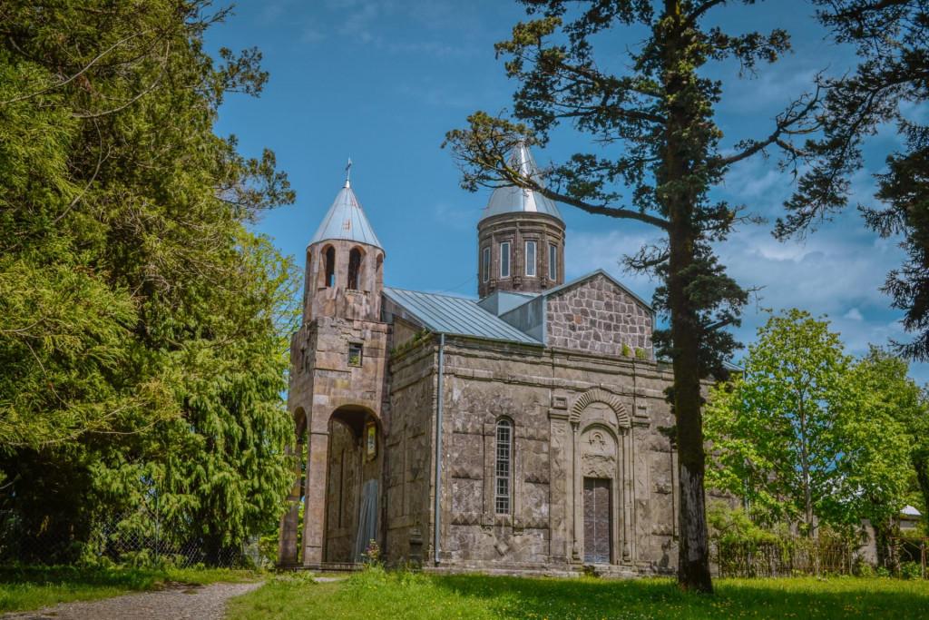 The Sameba-Jikheti Church is a 19th-century landmark located in the Guria region, within the Lanchkhuti Municipality, situated between the villages of Chqonagora and Sameba. It currently functions as a nunnery.
Jikheti is located on the northern slope of the Guria Range, on Nigoyiti Mountain, at an elevation of 250 meters above sea level. It is 12 km from Lanchkhuti, 3 km from Nigoyiti, and 6 km from the main highway.
The Monastery Complex
The monastery was founded at the end of the 19th century.
- The Main Temple: The Temple of the Presentation of the Virgin Mary was built in 1896 by Ilarion Menabde of Ozurgeti.
- Bell Tower: Added to the main temple in 1987.
- St. George’s Church: A basilica-type church built in 1988.
- St. John the Baptist Church: Built in 2002, dedicated to the Conception of St. John the Baptist.
- The Jordan Spring: A baptismal pool in the courtyard fed by spring water. The water is believed to have medicinal properties.
Every year on December 4th, the feast day of the Presentation of the Virgin Mary, the monastery hosts a major celebration known as "Jikhetoba."
Legend
There is a legend regarding the location of the Jikheti Monastery. Originally, a monastery named after the Holy Myrrh-bearing Women stood in a very inaccessible spot on Jikheti Mountain. The nuns suffered greatly from a lack of water and decided to choose a new location. Following a tradition reminiscent of the biblical flood, they entrusted the choice to three doves. The new monastery was built on the spot where the doves finally landed.
Lanchkhuti
- Hits: 73
 Lanchkhuti Municipality is located in western Georgia, on the Guria region. The territory of the district has been inhabited since the Stone Age. Urban life has been developed here since the Bronze Age, which is confirmed by the Shukhuti settlement. Lanchkhuti is first mentioned in historical sources in the 17th century. Scientists have different opinions regarding the etymology of Lanchkhuti. According to Simon Janashia's theory, this name is related to the Megrelian-Chan word chkhu, which means cow, and Lanchkhuti itself - to a cowshed. Vakhushti Batonishvili has a completely different opinion, in his opinion, the root of the toponym is "chku" and not "chkhu" and Lanchkhuti has the meaning of "samser", "gadashkhedi". By 1916, an elementary school and a library were already functioning in the district. In 1930, Lanchkhuti became the district center. Currently, the municipality has health care facilities, three public schools, a parish school, a cultural center, a library and a museum. Three regional newspapers are also published: "Lachkhuti +", "Lanchkhutis Moambe" and "Ho da Ara". Agriculture is developed in Lanchkhuti (citrus growing, livestock breeding, fruit growing), and tourism plays an important role in the coastal area. The Baku-Supsa oil pipeline and the Supsa terminal play a major role in the economy of the municipality. Lanchkhuti is also rich in minerals (peat, magnetite, limestone, clay, mineral water). The region is distinguished by its beautiful nature and ancient cultural monuments. The beautiful Kolkheti National Park, the Japanese Lake hidden in the green, the Paliastomi, medieval monuments and the sparkling blue sea with sandy beaches attract many tourists.
Geography and Climate
Lanchkhuti Municipality is located in western Georgia, in the Guria region, between the Black Sea, the Pichori River and the Guria Range. It covers the territory of the Odish-Guria Lowland and its adjacent mountains. The administrative center of the district is the city of Lanchkhuti. The municipality is bordered by the Black Sea coastline to the west,